
The Hamilton and Scourge Project: Past, Present and Future
Text by Michael McAllister and Ian Kerr-Wilson
Following publication of Civil Disobedience Wreck Diving in DIVER Volume 38 Number 7 the City of Hamilton expressed interest in outlining its initiatives and future plans for the Hamilton and Scourge historical site in its charge. This post is the FULL City of Hamilton report on the Hamilton and Scourge wrecks presented in the current issue – Volume 39 Number 2 – of DIVER Magazine, now available on newsstands.
Before dawn on August 8th 1813, two American merchant schooners capsized in a sudden summer squall. The two vessels, the Hamilton and the Scourge, had been converted to warships at the beginning of the War of 1812. At least 53 sailors lost their lives. The site was discovered in 1973. The shipwrecks are 1,640 feet (500m) apart at 295 feet (90m) below the surface of Lake Ontario 6.5 miles (10.5km) off Port Dalhousie. Both are intact, heeled over on their port sides with standing masts and decks strewn with artifacts such as boarding pikes, blocks and cutlasses.
The Hamilton and Scourge became a National Historic Site of Canada in 1976. Since 1980, the ownership and stewardship of this site has been the responsibility of the City of Hamilton.
Over 30 years, the site management has been through a number of phases and (inevitably) some ups and downs. The project has re-focused from planning for dry land conservation of one or more of the vessels to planning for long term in situ conservation. This change reflects evolving cultural resource management (CRM) practices and the emergence of sophisticated and effective non-intrusive archaeological techniques. In retrospect, the prudent approach to management has paid off. The vessels continue to exhibit a good state of preservation.
As CRM stewards, the City of Hamilton has created a management consultative committee of heritage presentation specialists, archaeologists, technical divers, underwater survey specialists, project managers, historians, engineers, conservation scientists and filmmakers. Every plan requires consultation with the United States Navy History and Heritage Command, Hamilton and Scourge Society, Parks Canada Underwater Archaeology Service, ASI Group Ltd., Canadian Coast Guard, Canadian Hydrographic Service and the Canadian Conservation Institute.
Prudent Approach to Management
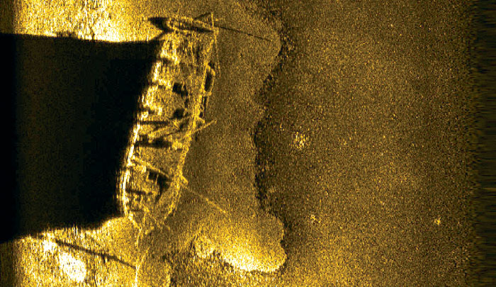
Cutting edge technology has always been a feature of the Hamilton and Scourge project. The National Water Research Institute and Royal Ontario Museum first located the wrecks using side scan sonar. In 1980, members of Jacques Cousteau’s team dived the wrecks sites in their mini-submarine producing 40 minutes of black and white video of each ship.
In 1982 National Geographic, in partnership with the City of Hamilton, captured more video and still images using a remotely operated vehicle. Reconstruction drawings were created that provided speculative views of the original look of the ships. All were included with an article by the lead project researcher Dr. Dan Nelson in the 1983 edition of National Geographic Magazine. Breathtaking images by Emory Kristof of the figureheads and other aspects of the ships showcased the rich material cultural resources found on board each wreck and scattered in the debris fields. An unfortunate entanglement in 1982 during ROV work led to accidental removal of the foremast of the Hamilton. The mast was subsequently re-deposited approximately 263 feet (80m) to the north and west of the ship. McQuest Marine carried out a side-scan sonar survey in 1983 to confirm the exact whereabouts of the mast.
The video and stills from the 80s were the subject of careful study by Dan Nelson, Ian Morgan, John Ames, Kevin Crisman and Ken Cassavoy. A detailed artefact and structural feature catalogue was created including detailed sketches. Four separate attempts at scaled plan view maps were also made showing the relationship between artifacts, ship structures, the debris fields and human remains – each slightly different due to the near to impossible task of accurately scaling the drawings. These drawings are still very useful because they were carried out before the appearance of quagga mussels. The drawings represent a significant contribution to the heritage presentation of the site.
In 1990 a partnership between the City of Hamilton, Canada Centre for Inland Waters and Wood’s Hole Oceanographic Institute led to more side scan sonar work in order to relocate the wreck sites and determine a safe location for mooring blocks for video and still imaging of the wreck sites. The 1990 survey was largely educational in nature producing several hours of video with commentary by Dr. Robert Ballard and Dr. Margaret Rule, formerly of the Mary Rose Trust. Archaeologically speaking the most significant contribution was the compilation of digital images from the starboard side of Hamilton into a mosaic. For the first time it was possible to gain a full view of one of the wrecks otherwise impossible due to water turbidity. The images are useful primarily as a record of the apparent preservation of the ships, associated debris field and human remains.
The first successful geo-referencing of the wrecks occurred in 2004/05 as a result of a multi-beam sonar survey conducted by the Canadian Hydrographic Service and ASI Group Ltd. That data was combined with a 2007 side scan sonar survey by Parks Canada and ASI Group Ltd. to create the first precise map of the lake bed with the wrecks shown in their proper orientation. Notable on the map were marks left on the lakebed surface by anchor drags. As well the new location of the foremast of the Hamilton was clearly visible. The new site map was very useful in the production of the mooring plan for the 2008 underwater survey. The Canadian Coast Guard vessel Griffon was instrumental in deploying a three-point mooring aligned to place the HMCS Kingston 295 feet (90m) offset from each wreck, thus minimizing the chance of damaging the vessels by unforeseen accidents.
The advance of technology allowed the 2008 underwater survey team to conduct the first reproducible condition monitoring survey. In CRM terms, condition monitoring involves observing structures, movable artifacts and landscapes over time in order to determine change. That involves being able to place the observer at the precise location of the original viewpoint each time. Interior views of the wrecks observed silt levels, mussel colonization and the presence of artifacts. A careful check was also made on the interior and exterior of each wreck to check on the condition of human remains found during previous surveys.
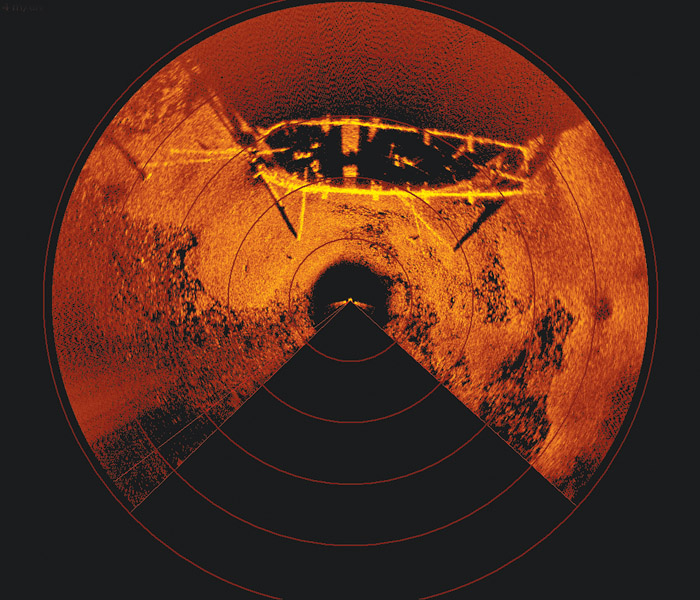
In 2008 and 2009, the on-site research achieved three breakthroughs: high resolution video; a low risk, non-invasive 3-D mapping process using dual axis sonar provided by ASI Group Ltd.; and new footage for a major television documentary by Yap Films. Perhaps most importantly, no damage to the wrecks occurred as a consequence of this recent research.
Jonathan Moore with the Parks Canada Underwater Archaeology Service recommended in his 2009 archaeological report that major condition monitoring/archaeological data recovery surveys should occur every three to five years. Funding for this work has been included in the City of Hamilton’s 10-year capital project planning process.
Over the short term monitoring is moving forward. Last June side scan sonar surveys were coupled with magnetometer sweeps to assess gross changes in hull structure, the extent of the mussel occupation and the distribution of iron artifacts across the site area. In turn, the City has started the consultation process with avocational dive groups for the purpose of receiving feedback on a volunteer monitoring program.

New Challenges
Sometime during the 1990s, quagga mussels began colonizing the shipwrecks. The invasion increased water clarity but also hid ship features and associated artifacts. While most of the deterioration of the vessels occurred in the prior 175 years, mussels now cause physical damage from increased weight on the fragile vessels and the removal of small amounts of wood when shells are dislodged. Mussels also cause chemical damage through the excretion of feces that decompose, resulting in oxygen level reduction or depletion in the immediate area. The depletion of oxygen may accelerate the iron corrosion of the guns and other iron components.
Environmental changes caused by mussel settlement pose the greatest new risk factor to the integrity of the resources. More research is needed to find creative solutions and the City continues to monitor industry best practices.
New Approaches to Preservation
Currently favoured is in-situ preservation as the first best option per the UNESCO Convention on the Protection of Underwater Cultural Heritage. As one of two provincially designated underwater archaeological sites, Hamilton and Scourge are off limits to unlicensed researchers. New partnerships and funding enhancements prepare the way for a volunteer monitoring program, artifact recovery plan, public access and site security.
This prudent non-invasive approach is important for several reasons. First Hamilton and Scourge are gravesites for at least 53 American sailors. Total excavation of the site would require the reverential recovery and repatriation for burial of those sailors who gave their lives 200 years ago. In the meantime, the remains demand our greatest respect.
Second, the ships will remain robust and solid as long as they are left largely undisturbed. They are composite artifacts of great complexity featuring a variety of different kinds of wood held together by wood and metal fasteners. The process of full recovery, or even recovery and conservation of portable artifacts is complex and extremely risky to the overall health of the vessels.
Third, the shipwrecks are a maze of masts, spars and gaffs protruding from the decks at different angles. The ships are heeled over on their port sides, complicating any approach that affords a good view given ideal water visibility of about 33 feet (10m).
Fourth, even with the best intentions, archaeology is an inherently destructive process. The ships are in their most authentic location in their most authentic condition sitting at the bottom of the lake surrounded by the debris field created as a function of sinking on August 8, 1813. Any major change of these conditions alters the authenticity of the resources. As much as possible the wrecks must be preserved in a way that preserves them intact in association with the means by which they ended up on the bottom in the first place.
Sharing the Story
The major challenge presented by the Hamilton and Scourge is to allow people to experience the shipwrecks while protecting the resources themselves and the last resting place of 53 American sailors. One process involves including the dive community in monitoring the shipwrecks. Operations of this kind will be subject to conditions set by the City of Hamilton and key regulatory bodies and stakeholders such as Parks Canada Underwater Archaeology Service, Canadian Conservation Institute, the Province of Ontario and the Niagara Regional Police.
Since 2007 in the lead-up to the Bicentennial of the War of 1812, the City of Hamilton coordinated four major memorial events both in Hamilton and on the waters of Lake Ontario featuring the general public, three levels of Canadian government, representation from the United States and British governments, the Office of the Lieutenant Governor of Ontario, bi-national veterans organizations, sport diving organizations, the United States and Royal Canadian Navies as well as the Canadian Coast Guard.
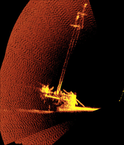
Three major heritage presentation initiatives are in progress. A new interactive virtual tour website featuring never before seen content which supplements the Hamilton & Scourge National Historic Site website was released in the summer of 2013. Sunken Sunset: Images from the Hamilton and Scourge 2008 underwater survey was on exhibit at the Art Gallery of Hamilton from June 22 to November 10 last year. The exhibit comprised stunning gold and orange computer renderings of the vessels on the bottom of the lake, beautifully constructed scale models of both vessels, a stunning painting of Hamilton and Scourge by noted artist Peter Rindlisbacher, and regular showings of Warships Down, produced by Yap Films. Portions of the exhibit are being incorporated into the Hamilton Military Museum’s new legacy exhibit entitled Blood Ties to a Gentle Landscape – the first phase of which opens in February 2014. Through interviews with descendants of historic personages, Blood Ties seeks to tell stories about people living on and around Burlington Heights during the War of 1812, including William and James Crooks, the original owners of the merchant schooner Lord Nelson (acquired, armed and renamed Scourge by the US Navy). Shipwrecked on a Great Lake, a new film currently in production under the direction of celebrated filmmaker Peter Rowe, is scheduled for release this summer.
In concert with planning for the long-term preservation of the site, consultation and planning continues for some form of permanent dry land interpretation of the wreck sites. The form this interpretation will take is still wide open but fullscale replicas, an interpretation centre and other memorials have been discussed and examined.
Conclusion
The essence of cultural resources management can be summarized as three tasks: preserve the resource for the long term; tell its stories in a compelling and inclusive way; and maintain financial sustainability.
Since 1980 the City of Hamilton has cultivated multi-level intergovernmental public/private partnerships in order to preserve the vessels, associated artifacts and the last resting place of 53 United States sailors. Consultation with partners and stakeholders in the management consultative committee is essential in the effective management of the Hamilton and Scourge National Historic Site of Canada. The City looks forward to continued engagement with the committee in moving forward with artifact recovery planning, pursuing funding for a visitor centre, a volunteer monitoring program and regular underwater surveys to monitor site conditions.
Michael McAllister has been the Project Coordinator for the Hamilton and Scourge National Historic Site since 2008. He holds Masters degree in Archaeology and is also the Curatorial Assistant at the Hamilton Museum of Steam and Technology. Ian Kerr-Wilson was Project Coordinator from 2000 to 2008. He holds Masters degrees in American History and Museum Studies and is now the Manager of Heritage Resource Management for the City of Hamilton.
2 Responses to “The Hamilton and Scourge Project: Past, Present and Future”
Leave a Comment


Chris Mills
Does anyone know the height of the figureheads on either Hamilton and Scourge?
Marg Barber
Hi
I am trying to seek permission to use an image from the Shipwreck the Hamilton and the Scourge for an educational school book I am working on. I am trying to contact the rights holder are you able to assist.
Your help would be greatly appreciated.
Regards, Marg Barber